Little Orphan Avenues: Ave Y and Ave Z in Bath Beach
On a recent trip, I went to fix out some of the last streets I need to walk in Bath Beach, which runs south to Bay 50th Street. I don't know where the boundary would or should be. At this point, below Bay 50th, I wasn't in Coney Island yet, so the only other thing you might call it is Gravesend. The streets align with Gravesend, but the train yard slices these streets away from the rest.
Basically, a bunch of streets and avenues are orphaned, cut off from the rest of their kind.
In short, my trip took me up and down one Bay street, four West streets (plus part of Stillwell Ave), two lettered avenues, a piece of Shore Parkway, and a short "place". I found that a couple streets listed on Google Maps do not exist, or they are private roads, even if they have names. The creepiest street, even in the middle of the day, was West 13th Street. It extends for one block in either direction from Ave Z, ending in Dead Ends in each direction. It is extremely isolated, but busy with trucks. (I counted eight cement mixers spinning on one lot.)
Okay, here are today's pictures (and apologies for the appearance while I get used to blogger's new "more friendly" user interface):
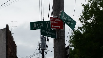
And now I know. It doesn't go anywhere! This picture is the entire length of Ave Y. There's a triangular plot of land, Private Anthony Catanzaro Square, bordered by Bay 50th and West 16th Streets. That's all of it. If you check Google maps, it doesn't even label it as Ave Y. (It does label a path just off of Stillwell Ave as Ave Y, but it doesn't exist. Or, if it does, it's behind a locked fence.)
|
|
|
And, finally, the saddest picture I took. Sad, because I feel sorry for any out-of-towners who made reservations, and ended up at the edge of nowhere. I took a peek at the parking lot. I didn't see an outlet to Stillwell Ave, so the wary traveler would have to negotiate whatever heavy equipment is out on West 13th Street. If you are walking, it's even worse. You have to walk back up to Ave Z, and then exit to Stillwell. At that point, you could either take a long walk back to Bay 50th Street, or a longer walk to Coney Island. The thing is, if you picked this place, you probably picked it because you wanted to be close to Coney Island. I wouldn't want to walk back here in the evening after a day at the beach. Call a cab.
|
|


Comments
Post a Comment